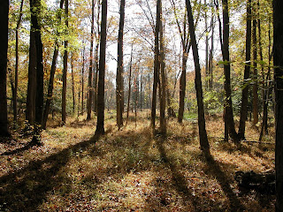
Stafford County is the location of Potomac Creek, and the Facebook page of the Stafford Museum and Cultural Center often posts information of interest to local denizens and other curious souls. Today's post is particularly useful since it addresses a topic that I -- as a helpless map worshiper -- have often wondered about but never bothered to look up (how many topics can we say that about?).
To wit: When talking about local waterways, what's the difference between a "creek," a "run," and a "branch?" These terms are old but still commonly used in our area. Housing developers, for example, often attach such terms to the new subdivisions they build. In fact, there is a new, completely clear-cut neighborhood of "McMansions" just up the road from where I'm writing this called "Potomac Run." The "Run" overlooks Potomac Creek. I often think of this naming practice as the developers' way of commemorating the natural feature they just irrevocably destroyed.
It turns out that these terms derive from the body of water's perceived utility to humans alone. What matters is whether or not a person can put a boat in it, walk through it, or jump across it. What a surprise!
Enough editorializing. Here's the Center's original FB post:
In this area, the bulk of the land grants and patents date from between 1651 and 1761. In these documents, property was frequently described using the terms river, creek, run, head, and branch. These terms continue in limited use today (according to their earlier definitions), but usually only amongst older county residents who grew up with an understanding of the words. For a researcher trying to determine the location or bounds of a particular early tract of land, an understanding of the words is useful. “River” is pretty much self-explanatory and we have here the Potomac and Rappahannock.
“Creek” refers to a tributary of a river that is deep enough to be navigable by boats of significant size. In Stafford, Aquia Creek and Potomac Creek would be examples. Now imagine that you are in a small rowboat and have traveled upstream on either Aquia or Potomac Creek beyond the point that most boats can go. The water becomes more and more shallow and once your little craft grinds to a halt, you have reached the “head” of the creek. Above this, Aquia Creek becomes Aquia Run and Potomac Creek becomes Potomac Run.
A “run” is not deep enough to float a boat but is wide enough that in order to cross it on foot, you will get your feet and pants legs wet. Continuing to progress upstream, once the run becomes narrow enough to hop across, it is considered a “branch.” The early surveyors and land records folks understood these terms, used them consistently, and they have distinct meanings in the patents and later deeds. It is worth noting that silting has altered the location of the “heads” of the creeks.
When George Brent (c.1640-c.1700) built his home at the head of Aquia Creek, he was able to take a small boat up as far as what is now called the Catholic Cemetery near the Crucifix. Due to the effects of silting, the “head” is now some distance downstream. During the early years of the eighteenth century, the head of Potomac Creek, as mentioned in the land patents, was about where Centerport Parkway crosses Potomac Run and Mountain View Road. Obviously, that head is also further downstream now.
' xlink:href='%23b'/%3e%3cuse fill='black' filter='url(%23c)' xlink:href='%23b'/%3e%3cpath fill='white' d='M12.162 7.338c.176.123.338.245.338.674 0 .43-.229.604-.474.725a.73.73 0 01.089.546c-.077.344-.392.611-.672.69.121.194.159.385.015.62-.185.295-.346.407-1.058.407H7.5c-.988 0-1.5-.546-1.5-1V7.665c0-1.23 1.467-2.275 1.467-3.13L7.361 3.47c-.005-.065.008-.224.058-.27.08-.079.301-.2.635-.2.218 0 .363.041.534.123.581.277.732.978.732 1.542 0 .271-.414 1.083-.47 1.364 0 0 .867-.192 1.879-.199 1.061-.006 1.749.19 1.749.842 0 .261-.219.523-.316.666zM3.6 7h.8a.6.6 0 01.6.6v3.8a.6.6 0 01-.6.6h-.8a.6.6 0 01-.6-.6V7.6a.6.6 0 01.6-.6z'/%3e%3c/g%3e%3c/svg%3e) Source: https://www.facebook.com/StaffordHistory.
Source: https://www.facebook.com/StaffordHistory.
All reactionsSource: https://www.facebook.com/StaffordHistory
N.B. (and final bit of editorializing) I do wish the post's author had written a little about why silting has altered the location of creek "heads." The tremendously destructive practice of clear cutting trees for new housing developments (completely unnecessary and ethically akin, in my view, to the mountain top removal processes still used by the coal mining industry), together with certain agricultural practices, are a very large part of that story.


.jpg)

Comments
Post a Comment